


Ship Radar - Ship Positions

Ship Radar - Ship Positions ၏ ရွင္းလင္းခ်က္
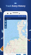
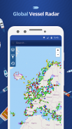
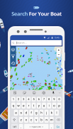
🌟 All vessels live on a map 🌟
➡️ You have the option to choose between 4 map types: Standard map, Simple map, Satellite map or OpenStreetMap
➡️ Every vessel type is marked in a specific color
➡️ You can explore plenty of different vessel types: Fish carriers, Crude Oil Tankers, Fishing Vessels, Other Tugs / Special Crafts, Bulk Carriers, Fire Fighting Vessels, Service Vessels, Passenger Ships, Training Ships, Yachts and much, much more
➡️ Besides vessels, the map contains ports and other locations
🌟 Search option 🌟
➡️You also have the option to search for specific vessels by IMO number or MMSI, ports, seas or other locations.
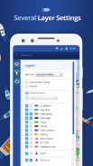
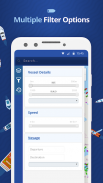
🌟 Filter option 🌟
➡️Sort out specific vessel types, so that you only get to see what you want to see.
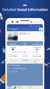
🌟 Vessel information 🌟
➡️ Get various pieces of vessel information by tapping on a vessel symbol such as speed, course and current status. You also get to see a picture of each vessel.
How does it work?
---------------------------------
We are using AIS data to provide you most accurate information. If you want to track vessels you just have to tap on "Start ship radar"
🌟အားလုံးတန်ဆာမြေပုံပေါ်တွင်အသက်ရှင်နေထိုင်🌟
➡️သင်ဟာ 4 မြေပုံအမျိုးအစားများအကြားရွေးချယ်ဖို့ကထို option ရှိသည်: နျ Standard မြေပုံရိုးရှင်းသောမြေပုံဂြိုဟ်တုမြေပုံသို့မဟုတ် OpenStreetMap
➡️တိုင်းရေယာဉ်အမျိုးအစားတိကျတဲ့အရောင်အတွက်မှတ်သားနေသည်
သင်ကကွဲပြားခြားနားသောအိုးအမျိုးအစားများများလေ့လာစူးစမ်းနိုင်ပါတယ်➡️: ငါးသယ်ဆောင်, ရေနံစိမ်းရေနံတင်သင်္ဘော, ငါးဖမ်းရေယာဉ်များ, အခြား Tugs / အထူးလက်မှုပညာ, အစုလိုက် Carriers, မီးသတ် Fighting ရေယာဉ်များ, ဝန်ဆောင်မှုရေယာဉ်များ, ခရီးသည်တင်သင်္ဘော, သင်တန်းသင်္ဘော, ရွက်လှေနှင့်အများကြီး, အများကြီးပို
➡️ရေယာဉ်များအပြင်မြေပုံဆိပ်ကမ်းများနှင့်အခြားနေရာများတွင်ပါဝင်သည်
🌟ရှာရန် option ကို🌟
➡️Youလည်း IMO နံပါတ်သို့မဟုတ် MMSI, ဆိပ်ကမ်းများ, သမုဒ်သို့မဟုတ်အခြားနေရာများအားဖြင့်တိကျသောရေယာဉ်များကိုရှာဖွေရန် option ရှိသည်။
🌟 Filter ကို option ကို🌟
သင်သာသင်မြင်ချင်အဘယ်အရာကိုမြင်ရနိုင်အောင်, တိကျတဲ့ရေယာဉ်အမျိုးအစားများကိုထုတ်➡️Sort။
🌟သင်္ဘောသတင်းအချက်အလက်🌟
➡️ထိုကဲ့သို့သောအမြန်နှုန်း, သင်တန်းနှင့်လက်ရှိအနေအထားကိုအဖြစ်အိုးသင်္ကေတပေါ်တွင်နှိပ်ခြင်းဖြင့်ရေယာဉ်အချက်အလက်များ၏အမျိုးမျိုးသောအပိုငျးပိုငျးကိုရယူပါ။ သင်တို့သည်လည်းတစ်ဦးချင်းစီရေယာဉ်၏ရုပ်ပုံကိုတွေ့မြင်ရပါတယ်။
ဒါကဘယ်လိုမျိုးအလုပ်လုပ်သလဲ?
---------------------------------
အကြှနျုပျတို့သညျအမြားဆုံးတိကျမှန်ကန်သတင်းအချက်အလက်များကို AIS ဒေတာအသုံးပြုနေသည်။ သငျသညျရေယာဉ်များကိုခြေရာခံချင်လျှင်သင်ရုံ "သင်္ဘောကိုရေဒါ Start" ပေါ်တွင်ထိပုတ်ပါရန်ရှိသည်
Ship Radar - Ship Positions - ဗားရွင္း 1.1.9
(15-12-2020)
Ship Radar - Ship Positions - APK သတင္းအခ်က္အလက္
APK ဗားရွင္း: 1.1.9package: com.sawischa.shipfinderShip Radar - Ship Positions ၏ ေနာက္ဆုံးဗားရွင္း
အျခား ဗားရွင္းမ်ား


က႑တူအက္ပ္မ်ား


